


ONSW mapping guru Russell Rigby just passed on details of an trans-government initiative to release spatial data freely under a creative commons license. The new model helps Australia catch up with other nations in terms of open access to geo-spatial data.
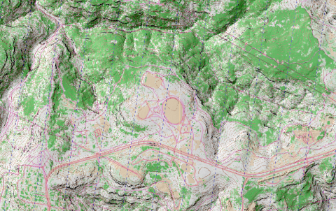
The tool ELVIS provides a relatively painless way to access the datasets that you need. Once you have them, they can be processed with commercial tools like OCAD or Arc/GIS or with free tools such as the excellent QGIS and Kartapaullatin applications. The image with this document uses the default settings from Kartapaullatin to generate the O-map style mapping along with some overlay of tracks from Open Street Map and hill-shading generated by QGIS. All free tools and data.
The coverage for NSW is far from 100%, but the coastal band is well covered.